
Chapter 9 Equations and Graphs

curves

In ancient Athens, around 430 BCE, one quarter of the city's residents perished in a plague. The people of Athens consulted the oracle at Delos, so the story goes, to find a cure for the plague. The oracle replied that they should construct a new cubical altar to the gods, and its volume should be double the volume of the existing cubical altar. Now, if the original altar had a side of length \(x\text{,}\) you can work out that the new altar should have side length \(\sqrt[3]{2} x\text{,}\) so that the new volume is \(2x^3\text{.}\)

two cubes

But the ancient Greeks could not use algebra to solve the problem -- it hadn't been invented yet. Instead, they used geometrical methods. The Delian problem of doubling the cube remained unsolved for many years. But sometime around 350 BCE, a mathematician named Menaechmus, who was the tutor to Alexander the Great, solved the problem, and in so doing invented the conic sections.

A "section" is a slice, and the conic sections are the curves formed by slicing a cone by a plane. Depending on the angle of the slice, we get four different curves, as shown below.

graph

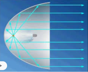
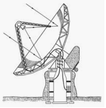
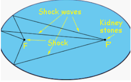
We have already met the parabola, which is described by the quadratic equation \(y=ax^2+bx+c\text{.}\) It turns out that the other conic sections are also described by quadratic equations. These curves have many interesting properties as abstract objects, but as often happens with mathematical discoveries, they are also useful in applications. Conic sections appear in art and architecture, in medicine, science, and engineering.

fireworks
operahouse
fountain
mollweide
Decca
ellipsestadium
headlight
sundial
telescope
whispering
sonicboom
orbits
bridge
navigation
lithotripsy
Investigation 9.1. Global Positioning.

The Global Positioning System (GPS) is used by hikers, pilots, surveyors, automobiles to determine their location (latitude, longitude, and elevation) anywhere on the surface of the earth. The system depends on a collection of satellites in orbit around the earth. Each GPS satellite transmits its own position and the current time at regular intervals.

A person with a GPS receiver on earth can calculate his or her distance from the satellite by comparing the time of transmission with the time when it receives the signal. Of course, there are many points at the same distance from the satellite—in fact, the set of all points at a certain distance \(r\) from the satellite lie on a sphere centered at the satellite. That is why there are several satellites: You calculate your position by finding the intersection point of several such spheres centered on different satellites.

We will consider a simplified, two-dimensional model of a GPS system in which the satellites and the receiver all lie in the \(xy\)-plane instead of in three-dimensional space.

In this model we’ll need data from two GPS satellites. The satellites are orbiting along a circle of radius 100 meters centered at the origin. You have a receiver inside that circle and would like to know the coordinates of your position within the circle.

grid

To make the computations simpler, we will also assume that the satellite transmissions travel at 5 meters per second.

  1. A signal from Satellite A arrives 18 seconds after it was transmitted. How far are you from Satellite A?

  2. The signal says that Satellite A was located at \((100, 0)\) at the time of transmission. Use a compass to sketch a graph showing your possible positions relative to Satellite A.

  3. Find an equation for the graph you sketched in part (2).

  4. A signal from Satellite B arrives 8.4 seconds after it was transmitted. How far are you from Satellite B?

  5. The signal says that Satellite B was located at \((28, 96)\) at the time of transmission. Use a compass to sketch a graph showing your possible positions relative to Satellite B.

  6. Find an equation for the graph you sketched in part (5).

  7. Your position must lie at the intersection point, \(P\text{,}\) of your two graphs. Estimate the coordinates of your position from the graph. (Remember that you are within the orbits of the satellites.)

  8. Later in this chapter you will learn how to find the coordinates of \(P\) algebraically by solving a system of equations. Verify that the ordered pairs \((28, 54)\) and \((68.32, 84.24)\) both satisfy the equations you wrote in part (3) and part (6). What are the coordinates of \(P\text{?}\)